Onshore project details
The onshore elements of the project are essential to transmit the electricity generated by the offshore wind park to an onshore grid connection point.
Cable route


Contains Ordnance Survey data © Crown copyright and database right 2012.
Map not to scale, for illustrative purposes only.
Roll over each frame to read a detailed description of the cable route section.
To view a more detailed map click here
Draft land plans
Draft land plans have been produced along the proposed associated onshore works. These can be viewed here.
Onshore overview
As part of its proposals, the Navitus Bay Wind Park will require a high voltage cable to connect the renewable energy generated by the wind park to the national electricity grid. To avoid the long-term visual impacts associated with overhead power lines, the cables would be placed underground.
The 35 kilometre (22 mile) underground route is proposed to run from the landfall point at Taddiford Gap, between Barton-on-Sea and Milford-on-Sea. This will run to a substation close to West Moors and Three Legged Cross, connecting into the Mannington substation owned by National Grid.
The route would consist of cable circuits buried underground. This is done by opening individual trenches and laying cables with a voltage up to 275kV, either directly into the ground or into ducts at a depth of approximately 1.5m. When construction is complete, the trenches would be covered and returned to their original state allowing access and farming to resume. In some cases the route may be drilled to avoid harming sensitive locations and infrastructure such as roads and railways.
The route was chosen after a rigorous year-long process of environmental surveys, engineering appraisals and discussions with landowners, local authorities and statutory conservation bodies, including Natural England and the Environment Agency.
 Click here to find out more
As part of this process, two other possible high voltage substation options were considered - Chickerell near Weymouth and Fawley in the New Forest. These options were not pursued due to various technical reasons, including proximity to sensitive habitat areas.
The onshore cable route to connect Navitus Bay at Mannington is longer than the connection at either Chickerell or Fawley. However, the offshore cable route is shorter. Environmental and engineering considerations associated with a shorter offshore cable route were major factors in determining Mannington as the preferred connection location.
Construction
If the project goes ahead, primary construction of the cable route, cable landfall and substation will take place over a period of two years. There will be a requirement to undertake some pre-construction works (for example, species translocation, fencing, vegetation clearance). Not all cables may be installed at the same time, so ducts will be laid which cables can be pulled into at a later date, outside of the primary construction period.
The landfall and cable laying activities would be temporary and the land would be returned to its natural state after the work has been done.
Cable landfall selection
To determine the preferred location for the offshore export cable to come ashore, Navitus Bay looked at a number of options and took into account a range of things including environmental factors and local geology. Taddiford Gap, between Barton on Sea and Milford on Sea, was chosen to minimise the impact of laying the onshore cable route on the local area.
Because of the narrow beach, height of the cliffs and to protect the seafront where the cable comes ashore, Navitus Bay is planning to use a Horizontal Directional Drill (HDD) design. This involves drilling a bore from the cliff, to an exit point below Mean High Water Springs. The submarine export cables will then be connected to the onshore cables by a transition joint, housed in an underground joint bay on the landward side of the landing point. The cables will be drilled sufficiently far back from the cliff, and sufficiently deep, to ensure they do not become exposed due to erosion nor contribute to the natural erosion rates.
Joint bays are usually concrete-lined structures, accessed through a manhole cover. It is likely our joint bay will be around 12m long, 3m wide and 3 metres deep.
Cables
There will need to be a range of onshore cables such as:
- HV onshore cables – which will carry power from the landfall point to the planned new onshore substation.
- HV transmission cables – which will connect the substation to the existing grid connection point at Mannington (the point where electricity is transferred into the national electricity network).
If the wind park goes ahead, the electrical infrastructure including the onshore cables would be designed to take into account such things as turbine type and size, wind park capacity and ground conditions.
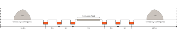
Indicative working width for cable installation.
Click on image to expand
If consent is granted, Navitus Bay will select the most appropriate type of cable technology during the detailed design phase and when more information, such as the completion of the procurement process, is known.
Substation
All forms of generation require a substation to enable power to be distributed either locally or nationally and Navitus Bay is no exception. An onshore substation is needed to transform the electricity generated by the wind park up to the voltage of the National Grid.
In November 2011, Navitus Bay asked for views on the two proposed locations for the onshore substation. Using the consultation responses, along with environmental survey data and further technical information, Navitus Bay carried out an assessment of the potential impact of the substation locations on the local environment. It determined that the eastern location for the substation had the lowest potential impact. As a result, the proposed 35km underground cable will run to a substation close to West Moors and Three Legged Cross, near the substation owned by National Grid at Mannington.
The substation will require a compound of electrical equipment to transform the electricity generated by the offshore wind park. The compound will be approximately 3 hectares (7.5 acres) in area, with a maximum height of infrastructure of up to 14 metres whilst electrical equipment may be up to 11 metres high.
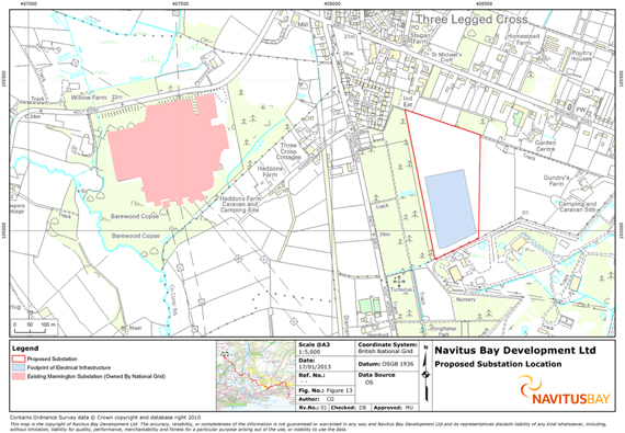
Map shows location of the proposed substation and footprint of the electrical infrastructure within it.
Click on image to expand


