Proposals
A map of the area selected for development is shown below:
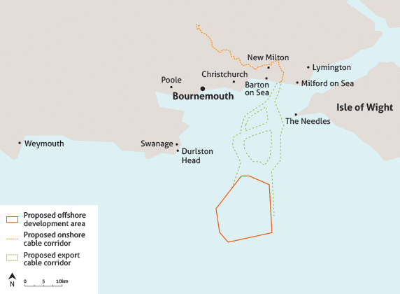
Contains Ordnance Survey data © Crown copyright and database right 2013. Map not to scale, for illustrative purposes only.
The boundary of the proposed offshore development area shown here has changed since the original development plans were drawn up. These changes, announced in December 2012 and February 2014 respectively, were made in response to feedback received from public and statutory consultees during the rounds of public consultations that Navitus Bay conducted. To see how the boundary of the wind park has changed to date please click on the link below:
Navitus Bay's planning application will include a range of turbine sizes, heights and quantities. This principle is known as the ‘Rochdale Envelope’ and is a well-established approach to planning consent for offshore wind parks in the UK. It is important that flexibility is allowed for the final configuration given that turbine technology is evolving at such a rapid pace.
This approach fixes key parameters, such as the maximum number of turbines, maximum dimensions and the maximum installed capacity of the project. It uses these parameters to assess the realistic worst case scenario. Whilst being robust when assessing potential environmental impacts, it allows us to construct the most efficient scheme available.
Project Statistics
 Site area
The total area of seabed that will be developed is 153 square kilometres (59 square miles).
Water depth
This ranges from 32 metres to 53 metres.
Number of turbines
Between 121 and 194.
The maximum number of wind turbines will be 194, based on the use of 5MW turbines.
Size of turbines
A maximum tip height of 200m and maximum rotor diameter of 176m (for an 8MW capacity turbine). Currently a 5MW turbine would be up to 177m to tip with a rotor diameter of 154m.
Target capacity
An approximate installed capacity of 970MW.
Electricity generated
Electricity generated: In a typical year it is estimated that the Navitus Bay Wind Park could generate 3.0 terrawatt hours (TWh) of electricity a year. This is the equivalent of generating enough electricity for around 700,000 average UK households.
Based on DECC’s 2005-2012 average annual domestic household electricity consumption of 4,229kWh.
View source
The figure has been calculated with a site-specific capacity factor of 35%.
CO2 emissions avoided
Approximately 1,290,000 tonnes of carbon dioxide per year.
Based on a figure of 430g CO2/kWh, calculated using Renewable UK’s “CO2 Reduction (pa) in Tonnes” methodology. View source
Distance to shore from current proposed nearest points
boundary (2014)
boundary (2012)
Appearance from shore
Click here for viewpoints from various locations
Click here for frequently asked questions


