Onshore elements
In order to transmit the energy generated offshore on to the national electricity grid, Navitus Bay requires a cable route and onshore substation. On this page you can see how the onshore substation may look and view a detailed map of the proposed cable route.
The onshore elements of the project start at the landfall, located at Taddiford Gap between Barton-on-Sea and Milford-on-Sea. The 35km (22 mile) underground cable route goes past Hordle, around New Milton, and passes Hinton, Sopley and Avon before heading through West Moors to the substation site in Three Legged Cross.
Draft land plans have been produced along the proposed associated onshore works.
 To view the land plans click here:
Land plan key plan
Download: PDF document, 9.17MB
Land plan sheet 1
Download: PDF document, 2.53MB
Land plan sheet 2
Download: PDF document, 3.05MB
Land plan sheet 3
Download: PDF document, 3.21MB
Land plan sheet 4
Download: PDF document, 2.97MB
Land plan sheet 5
Download: PDF document, 2.56MB
Land plan sheet 6
Download: PDF document, 2.36MB
Land plan sheet 7
Download: PDF document, 2.31MB
Land plan sheet 8
Download: PDF document, 2.38MB
Land plan sheet 9
Download: PDF document, 2.32MB
Land plan sheet 10
Download: PDF document, 2.42MB
Land plan sheet 11
Download: PDF document, 2.38MB
Land plan sheet 12
Download: PDF document, 2.78MB
Land plan sheet 13
Download: PDF document, 2.87MB
Land plan sheet 14
Download: PDF document, 2.53MB
The draft land plans can also be viewed at these locations:
Libraries
New Milton Library, Gore Road, New Milton, BH25 6RW
West Moors Library, Station Road, West Moors, Ferndown, BH22 0JD
Parish council offices
Bransgore Parish Council, The Village Hall, 116 Burley Road, Bransgore, BH23 8AY
Holt Parish Council, Stone Cottage, Hinton Martell, Wimborne, BH21 7HE
Hordle Parish Council, The Council Office, Vaggs Lane, Hordle, Lymington, SO41 0FP
Hurn Parish Council, 27 Moorside Road, West Moors, Ferndown, BH22 0EH
Milford-on-Sea Parish Council, The Old Clock House, 22 High Street, Milford on Sea, SO41 0QD
New Milton Town Council, The Town Hall, 2 Ashley Road, New Milton, BH25 6AS (please ask to view the maps)
St Leonards and St Ives Parish Council, The Parish Office, The Village Hall, Braeside Road, St Leonards, Ringwood, BH24 2PJ
Verwood Town Council, Council Offices, 28 Vicarage Road, Verwood, BH31 6DW
West Moors Parish Council, 4 Parkway, West Moors, Ferndown, BH22 0HL
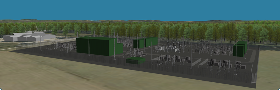
How will the onshore substation look?
You can see how the substation would look from six viewpoints.
Viewpoint 1 Gundry’s Farm (Photomontage Year 1)
Download: PDF document, 11.36 MB
Viewpoint 1 Gundry’s Farm (Photomontage Year 15)
Download: PDF document, 11.38 MB
Viewpoint 2 Public footpath to the north of Sturts Farm
Download: PDF document, 10.5 MB
Viewpoint 3 Bridleway to the north of Woolsbridge Industrial Estate
Download: PDF document, 8.59 MB
Viewpoint 4 Public footpath on Holt Heath
Download: PDF document, 8.62 MB
Viewpoint 5 Bridleway on Horton Common (near Redman Hill)
Download: PDF document, 8.22 MB
Viewpoint 6 Redman’s Hill
Download: PDF document, 14.9 MB
Please note the size of these files: they may take a while to download.
To download and read more about how the image was created and how it should be viewed, please click here.
Where does the cable route go?


Onshore cable route - Contains Ordnance Survey data © Crown copyright and database right 2012. Map not to scale, for illustrative purposes only.
Roll over each frame to read a detailed description of the cable route section.
To view a more detailed map click here


